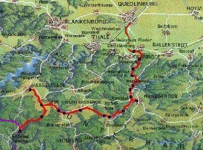
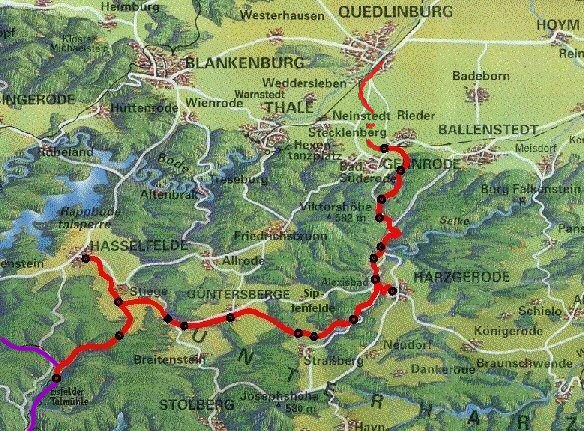
(zum Vergrößern Grafik anklicken - 128 KB)
| Map | Statistics | Vertical section | Description |
(zum Vergrößern Grafik anklicken - 128 KB)
If the mouse pointer on certain areas is in the card, in the status line the station name is displayed, if your Browser permits Javascript.
After mouse-click there starts jump to the belonging passage in the text. From the end of the passage in the text a return jump is possible to the card.
| Station / flagstop | Position in km |
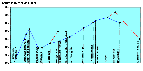
Heights over the sea level in m |
Station / flagstop | Position in km |
Heights over the sea level in m |
|
| Gernrode | 0,0 | 204 | ||||
| Osterteich | 1,46 | 211 | ||||
| Sternhaus Haferfeld | 5,71 | 381 | ||||
| Sternhaus Ramberg | 6,91 | 413 | ||||
| Mägdesprung | 10,17 | 295 | ||||
| Drahtzug | 11,61 | 298 | ||||
| Alexisbad | 14,55 | 325 | Alexisbad | 0,0 | 325 | |
| Silberhütte | 17,7 | 335 | Harzgerode | 2,9 | 400 | |
| Straßberg Glasebach | 21,3 | 361 | ||||
| Straßberg | 21,81 | 363 | ||||
| Güntersberge | 27,03 | 420 | ||||
| Friedrichshöhe | 30,52 | 454 | ||||
| Albrechtshaus | 31.32 | 467 | ||||
| Stiege | 35,71 | 485 | Stiege | 0,0 | 485 | |
| Hasselfelde | 40,38 | 452 | Birkenmoor | 2,9 | 520 | |
| Eisfelder Talmühle | 8,95 | 352 | ||||
| net of GHE | 52,23 | km | ||||
| other net of HSB | 79,46 | km | ||||
| whole railway net of HSB | 131,69 | km | ||||
| part of HSB-network | 39,6 % | |||||
(to zoom out click on the graphic - 15 KB)
We go on a journey over the network of the Selketalbahn with a uninterupted steam train which operated with the summer time-table in 1998/99. As ticket the Selkebahnticket is recommended.
Station Gernrode is the only direct transition between the narrow-gauge network of the former Gernrode-Harzgerode railway (GHE) and the DB AG (German railway company).
Arriving from the normal-gauge line Frose - Quedlinburg travelers from the directions of the towns Halle, Halberstadt and Goslar have the possibility of change for the trains of the Selketalbahn.
The narrow-gauge section of the station is approximately so long as the standard-gauge section. The connection of both networks forms a retractor ramp, over which narrow-gauge vehicle could be loaded on standard gauge cars. Since start of the 1990's however this procedure is not used any longer. Still longer the reloading shed is in use. It was replaced in the middle of the 1960's by a crane installation, with which since then all goods between both gauges were reloaded. The reloading shed forms the westernmost end of the railway tracks of the narrow-gauge section. Before it the coaling facility was situated. Since however a crosswalk was left open in 1998, the supply with hard coal by truck proves as problematic. Therefore the coaling facility was shifted in eastern direction. Beside the usual facilities of a railway terminal the field-forge and a siding with historical vehicles are worth mentioning. The forge is a section of the former waiting building of flagstop Osterteich. It was converted by members of the friend of Selketalbahn into a museum. The stored cars are likewise under maintenance of our association. They are partly executable and from time to time used into special trains.
Geologically seen Gernrode is directly of the foot of the powerful refuge of the Harz. In the case of its elevation the layers placed themselves partly perpendicularly, which is to be seen impressive at the shelly limestone wall at the quarry of the former lime burning plant Gernrode. The mountain is called "Bückeberg" and is 250 m highly.
Over the railway overpass with the highway Gernrode - Rieder (without barriers) runs the track in far curves toward "Ostergrund" (valley Easter-ground). On the right stand new houses, which settle the free meadow surface up to the Osterallee from center of the 1990's.
The open-air swimming pool "Osterteich" (Easter pond) on the left side marks the input to "Ostergrund" and the edge of Harz. Immediately
after it the train passes the flagstop Osterteich (requirement stop). A sign is sufficient as configuration. The platform differs from the area around only by a gravel filling. Rising and in the distance process adapted to the mountain-slope of "Ostergrund" it constantly goes approximately up. Best landscape views has one here from the left side. Only few bridges were to be established for the route. A small bridge crosses an insignificant side valley and a short time later becomes the view freely on the second pond of this valley, the "Heiligenteich" (Holy pond). A small bay of the pond the train overcomes by a bridge and the journey continues to go through beech mixed woodland.
The next flagstop is called Sternhaus Haferfeld and is just as sumptuously equipped, as Osterteich. Immediately after traversing the highway Gernrode - Sternhaus is achieved the upper end of the valley "Ostergrund". The meadows on the left side mark the source area of the brook "Wellbach" (waving brook), which flows through the "Ostergrund".
Still the line climbs and after few minutes the first vertex is achieved at the station Sternhaus Ramberg on a height of 413 m. There is nevertheless here still another crossing track that one uses during special travels. Around the flagstop spreads a magnificent beech forest. The height of the flagstop Sternhaus Ramberg" is belonged to the powerful granite body of the mountain "Ramberg". One can achieve its highest peak, the "Viktorshoehe" with 581 m from here on comfortable ways for hikers.
Driving downhill begins just as winding as the uphill drive. With each kilometer, which the train drives, it lost 25 m at height. This inclination is the steepest of the entire network of the HSB. The forest is loosened up now and then by some meadows. Left a weekend house appears on a meadow and latest one notices now, that this is the first house since the flagstop Osterteich. Up to the station Mägdesprung is not to be seen a settlement. The course takes unimpaired its way and one becomes already thoughtful, why the upward gradient-moderately more favorable way was not taken starting from Rieder by the lower Selketal. Particularly since still some hammer factories would have provided here for freights. However before the railway construction the area did not belong to the duchy Anhalt-Ballenstedt.
Briefly before the station Mägdesprung before the first crosswalk the track goes in a left curve around the mountain top of the "Heinrichsburg" (mountain with a ruin of a castle). Then one crosses twice road B 185. Both transitions were equipped in the past with modern safety engineering (automatical barriers). Mägdesprung was until 1888 railway terminal of the line. Today trains can cross here. The former load track at the goods shed serves only maintenance vehicles. One gets tickets in the restaurant.
Here in Mägdesprung the former landowner let built up an industry structure for ironworks. Miners promoted ore that was converted to irons on the spot. Wood and water were likewise available as secondarymost important raw materials.
Starting from Mägdesprung now finally the Selketal (Selke-valley) is achieved. High mountain-slopes, at which trees and rock alternate, climb steeply. The rocks consists of "Grauwacke" (gray sandstone), deposits out of a time before approximately 370 million years. The difference in height between Selke (river) and mountain top amounts up to 100 m. The valley with its many curves gives the further process of the railway line. On the right the slope clims upward and left the Selke runs. To Alexisbad the train will not leave the right slope page. In the places, in which the natural curves are too close, the designers of the line created laboriously rock break-throughs. They were sufficient even for the narrow-guage trains. With the application of the diesel locomotives this had to
be widened at the end of the 1980's. From the platform of the last car the three rock cuts - being situated briefly before and after the flagstop Drahtzug - can be experienced best.
At the flagstop Drahtzug the train holds very rarely (stop on demand). The engine driver must hold here precisely with the platform of the first car at the platform of the flagstop, because this is 10 m long and shorter than all at present available passenger cars of HSB. There is a sign and the name reminded of a in former times available wire drawing. Also the house directly at the road before Drahtzug refers with the name "Stahlhammer" (steel hammer) to the old trade.
Behind Drahtzug, directly at the second rock cut (km 12.5), is the Selkewasserfall (Selke-waterfall). Soon after passing the last rock cut the first houses of Alexisbad, a local part of Harzgerode, become visibly. On a short bridge at the "Klostermühle" (monastery mill) the "Friedenstalbach" (Peace-valley-brook) is crossed and directly to it the valley page is changed for the first time. The railroad level crossing with the local road is secured with barriers. Closely with the edge of the river Selke, along a retaining wall the track continues to the station. Left one sees the small chapel and on the right holiday homes and hotels. By the way, after a devastating flood in April 1994 this line section had to be structured again.
Alexisbad is probably the most famous station in the network of the Selketalbahn. Holiday-maker swarms of the hotels, strollers and hikers of the delightful ways and railway fans of the legendary double departures of steam trains toward Harzgerode and Silberhütte. It gives the double departures since June 1997 only on special travels. A railway lives evenly mainly on its passengers.
The station Alexisbad has three tracks and a load track. It is water station for all steam trains and not rarely here likewise are stationed maintenance vehicles. The historical clock and the departure board at the station building again and again pull views of itself. In former times the station restaurant was famous for its Knoedel, which were served with Gulasch and vegetables. For historians it is noticed that from the coal soil of the goods shed briquettes were saved, whose press date is situated still 1945 ago.
First we drive on the branch of line from Alexisbad to Harzgerode. After short parallel travel to the route to Straßberg the track continues over the first larger Selke-bridge into a side valley in constant uphill drive. Twice one crosses at secured way transitions highway B 185. Again the line runs at the right mountain-slope. Two tight bends artificially had to be wrung out the rock. After the second crosswalk the valley widens, the salient square water tower of Harzgerode and the first houses come into the field of vision. Past at the "Judenteich" (Jew pond) and at the "Hahnröderteich" (Hahnröder pond) is achieved the town. After traversing the last barrier the route takes short upward to the station.
Harzgerode is achieved. A track for transfering the locomotive is sufficient. The old connection tracks for the local industry do not exist any longer. Only the load track at the goods shed is still available. Station building was to be already seen in this architectural style in Alexisbad and Mägdesprung. To start of the 1990's there was the last goods traffic with narrow-gauge cars here by the Deutsche Reichsbahn (German National Railroad). After reloading standard-gauge freight cars in Gernrode aluminum blanks were supplied to the "VEB Druckguß- und Kolbenwerke Harzgerode" (state company "pressure pouring and piston factories Harzgerode"), which manufactured from it cylinders for the vehicle industry. The small town is worth seeing for the tourist and who has desire, hikes the few kilometers after Alexisbad back.
The second departure of Alexisbad leads now again uphill in the Selkevalley. Constantly however gently rising the track runs at the right valley page in driving direction beside the river Selke. Directly around the Selke a dense break forest spreads. More frequently spruces are on the mountain-slopes. Without larger views the train achieves Silberhütte and climbs the slope. Down the area of a pyrotechnic factory. A bridge, those on both pages is flanked by a high fence leads across a factory road. Briefly after it one passes the fourth rock cut of the route and a little later the train arrives the station Silberhütte and locks thereby the road Alexisbad - Straßberg.
Silberhütte with the addition by the railway authorities "Anhalt" has a small station building with goods shed. It is developed to a forest information center and used thus again. One can buy tickets there only in the trains. From the two connection tracks only the track to the former heating station still remained. Additionally to this a bridge belongs over the river Selke. At the heating station a 120 m high chimney stood out from the valley. For supply regularly coal cars from Nordhausen via Stiege rolled directly after Silberhütte. The warmth arrived the pyrotechnic factory via a piping. But in the meantime all up to pyrotechnics Silberhütte is history.
On the right station page is a division of the "Harzer Holzwerke Rinkemühle" (Harz wood factories). After the departure, crossing of the "Uhlenbach" (Uhlen-brook) and renewed railroad level crossing with the road to Straßberg left a further division becomes visible. This factory had likewise a connection track. Old photos show highly loaded open cars with wooden barrels as characteristic charge of this factory.
The Selke-valley widens. Willows stand along the waterfront. The difference in height of the valley to the top of the mountains amounts to only about 60 m.
Mountain-slopes becomes gentle. The train arrives the nice village Straßberg. The village consists since 1952 of the parts Lindenberg on the right mountain-slop and Straßberg on the left mountain-slop. River Selke divides the Prussian province and the duchy Anhalt-Ballenstedt. In the past miners found ore. The show mine "Grube Glasebach" can be visited. To have a shorter way to the mine the flagstop Straßberg Glasebach was opend in 1994.
In Straßberg the track runs through the middle of the village. Railway line, road and river Selke divides the place between the houses. The local road is crossed and short thereafter the train keeps at the platform. The crossing track was attached with returning switches in context with reconstruction of the railway line to Stiege. If trains cross here, complex locking of the switches is omitted.
The journey continues to go, whereby after few minutes the train changes of the right to the left valley side. Exactly occurs at the branch to the former loading point "Herzogschacht" (duke-mine). Starting from here a connecting track from the valley led to the fluor-spar pit. Fluor-spar as an important raw material for metal preparation, among other things uranium, was after the end of World war II the principal reason for the reconstruction of the Selketalbahn, which already was dismantled for reparations up to the line section Straßberg - Herzogschacht.
At the metal bridge over the Selke starts the in 1983 rebuilt line section to Stiege. Main reason for the reconstruction was the supply of the heating station Silberhütte with coal. In the wide Selke-valley, by whose meadows the river winds itself and whose silence is not disturbed by road noise, it goes to Güntersberge.
Until 1890 the journey were terminated in Güntersberge. Only after it the railway company continued to build the track toward Stiege. Today from the former railway terminal with locomotive shed only station building exists. The platform is fastened with gravel filling, sidings were not again structured in 1983. The settlement is situated on the right in the valley. Güntersberge is the smallest town of Saxonia-Anhalt and possesses its own city hall.
After the departure the train drives along on the bank of the "Bergsee" (mountain lake), which is used in the warm season as open-air swimming pool and additionally ther is a boat rental business. From the upper end one has a beautiful view over the lake on the town, which is towered above by the church with its remarkably covered roof. Left up at the mountain-slope the last remainders of the Güntersburg (ruin of Günter-castle) are situated in the forest hidden.
The valley becomes now again narrower. Still there are meadow surfaces on the left and on the right of the Selke, but the forest ever more moves close near. The route runs already between the spruces along.
The next station Friedrichshöhe has beside a waiting hall from precast concrete parts in the style of the 1980's a crossing track. Behind the station the trains traverses the connecting road of village Friedrichshöhe to highway B 242.
Flagstop Albrechtshaus is the last station in the Selketal. A platform and the stationsschild serve as equipment. With the bus waiting building beyond the road it concerns the former waiting house of railway the flagstop.
In this local part of Stiege there is a wooden church worth seeing. The line climbs off here again more strongly uphill, in order to achieve the high area before Stiege. The surrounding damp meadows form the source area of the river Selke. With the vertex of the line on the high surface the train concerned now in the catchment area of the brook "Hassel".
Far now the view curves over the high area. The damp meadows are used agriculturally as pasture.
The houses of Stiege come into range of vision and directly on the right of the station is situated the "Oberteich" (upper pond), while on the left the route from Eisfelder Talmühle leads into. The railway tracks of the station are generously limited. Three main tracks permit the arrival of trains from all directions. Besides a load track exists. Most attention pulls again and again the turning circle on itself. It was built during rebuilding of route to Straßberg. Using the turning circle freight trains from Nordhausen or Silberhütte could drive on to the other direction without transfering the locomotive. Return switches saved further processing steps and additional personnel application. In the past the switches were converted, so that trains from Nordhausen can drive on directly to Hasselfelde. Each travel by the turning circle is now connected with a switch operation, which one practices only for special travels. The extensive railway tracks make Stiege again and again the target for special meetings like vehicle exhibitions.
The journey goes on to Hasselfelde, the second terminator point of the terminal station. The line runs over the high area and climbs thereby still another piece. If the highest point of the area is achieved, with good view the mountain Brocken comes into the field of vision on the right page. Before it the houses of Hasselfelde are situated. Briefly before the settlement the train turns to the left and brings in into the station. Station building with its wood boarding deviates in the architectural style from the seen buildings, however it is of a landscape-typical style. A loading ramp and the continuation of the line connection track still reminds on the freight traffic here. The locomotive shed is regenerated. It serves from time to time storing any longer not used locomotives. Generally the trains have only few stay up to the return trip to Stiege.
Returned to Stiege train has to drive last by GHE built line section to Eisfelder Talmühle - the connection to the route Nordhausen - Wernigerode (Harzquerbahn = Harz crossing railway).
Briefly behind the station Stiege leads the track toward Eisfekder Talmühle dead-straight to the north. On this section in 1928 test runs with the rocket vehicle "Eisfeld Valier" were undertaken. Vehicle was built in Silberhütte. On the right the view curves over the hieg area, on its horizon is to be seen the mountain Brocken.
Then the beech mixed woodland is achieved around Birkenmoor (birch moor). At the flagstop with the same name only few travelers get in / off. Here a sign and a up-poured platform meet the request.
Until Eisfelder Talmühle route goes now constantly downhill. The brook "Behre" cuts into the valley. Left slope is towered by the mountains "Großer Behrekopf" and "Kleiner Behrekopf" (Great and Little Behre-head). Above the right slope the 528 m of the high mountain "Harzgeroder Berg" (Harzgerode mountain) is to be seen. Forest and smaller meadows stand along the railway line. Here in the "Behretal" (Behre-valley) two larger stone-bridges were to be established, in order to cross the side valleys of "Barschenkulk"-brook and "Mosebach" (Mose-brook). After the winding travel the line passes the largest freight customer of the HSB, the quarry "Unterberg" (Under mountain). A connecting track is for parking freight cars. Until the end of the 1970's here was a flagstop for commuters traffic.
At the end of the valley the brook is crossedof on a metal bridge. The track leads now parallel the track from Wernigerode to the station Eisfelder Talmühle (ice-field valley-mill). This station as former station of two railway companies has still extensive railway tracks. Three tracks are used for the passenger traffic, one as locomotive driving track to the former locomotive shed and two further than siding for freight cars. The station building in framework construction remains vacant.
Except to the station Eisfelder Talmühle it does not give further houses. Who regards the surrounding attentively can notice that here seven valleys collide. Reason for the
building of the station even here were above all topographic considerations.
Thus the journey on the network of the Selketalbahn, the former Gernrode Harzgerode railway company (GHE), is terminated.
| history of railway | time-table of HSB |